Showing posts with label Ancient Civilizations. Show all posts

Feb 23, 2023

Archaeologists uncover early evidence of brain surgery in Ancient Near East

Archaeologists know that people have practiced cranial trephination, a medical procedure that involves cutting a hole in the skull, for thousands of years. They've turned up evidence that ancient civilizations across the globe, from South America to Africa and beyond, performed the surgery.

Now, thanks to a recent excavation at the ancient city of Megiddo, Israel, there's new evidence that one particular type of trephination dates back to at least the late Bronze Age.

Rachel Kalisher, a Ph.D. candidate at Brown University's Joukowsky Institute for Archaeology and the Ancient World, led an analysis of the excavated remains of two upper-class brothers who lived in Megiddo around the 15th century B.C. She found that not long before one of the brothers died, he had undergone a specific type of cranial surgery called angular notched trephination. The procedure involves cutting the scalp, using an instrument with a sharp beveled edge to carve four intersecting lines in the skull, and using leverage to make a square-shaped hole.

Kalisher said the trephination is the earliest example of its kind found in the Ancient Near East.

"We have evidence that trephination has been this universal, widespread type of surgery for thousands of years," Kalisher said. "But in the Near East, we don't see it so often -- there are only about a dozen examples of trephination in this entire region. My hope is that adding more examples to the scholarly record will deepen our field's understanding of medical care and cultural dynamics in ancient cities in this area."

Kalisher's analysis, written in collaboration with scholars in New York, Austria and Israel, was published on Wednesday, Feb. 22, in PLOS ONE.

Two brothers, up close

Israel Finkelstein, who co-authored the study and serves as director of the School of Archaeology and Maritime Cultures at the University of Haifa, said that 4,000 years ago, Megiddo stood at and controlled part of the Via Maris, an important land route that connected Egypt, Syria, Mesopotamia and Anatolia. As a result, the city had become one of the wealthiest and most cosmopolitan cities in the region by about the 19th century B.C., with an impressive skyline of palaces, temples, fortifications and gates.

"It's hard to overstate Megiddo's cultural and economic importance in the late Bronze Age," Finkelstein said.

According to Kalisher, the two brothers whose bones she analyzed came from a domestic area directly adjacent to Megiddo's late Bronze Age palace, suggesting that the pair were elite members of society and possibly even royals themselves. Many other facts bear that out: The brothers were buried with fine Cypriot pottery and other valuable possessions, and as the trephination demonstrates, they received treatment that likely wouldn't have been accessible to most citizens of Megiddo.

"These brothers were obviously living with some pretty intense pathological circumstances that, in this time, would have been tough to endure without wealth and status," Kalisher said. "If you're elite, maybe you don't have to work as much. If you're elite, maybe you can eat a special diet. If you're elite, maybe you're able to survive a severe illness longer because you have access to care."

In her analysis, Kalisher spotted several skeletal abnormalities in both brothers. The older brother had an additional cranial suture and an extra molar in one corner of his mouth, suggesting he may have had a congenital syndrome such as Cleidocranial dysplasia. Both of the brothers' bones show minor evidence of sustained iron deficiency anemia in childhood, which could have impacted their development.

Those developmental irregularities could explain why the brothers died young, one in his teens or early 20s and the other sometime between his 20s and 40s. But Kalisher said it's more likely that the two ultimately succumbed to an infectious disease. A third of one brother's skeleton, and half of the other brother's, shows porosity, legions and signs of previous inflammation in the membrane covering the bones -- which together suggest they had systemic, sustained cases of an infectious disease like tuberculosis or leprosy.

Kalisher said that while some skeletal evidence points to leprosy, it's tough to deduce cases of leprosy using bones alone. She's currently working with researchers at Germany's Max Planck Institute for Evolutionary Anthropology to conduct DNA analyses of specific lesions in the bones. If they find bacterial DNA consistent with leprosy, these brothers will be among the earliest documented examples of leprosy in the world.

"Leprosy can spread within family units, not just because of the close proximity but also because your susceptibility to the disease is influenced by your genetic landscape," Kalisher said. "At the same time, leprosy is hard to identify because it affects the bones in stages, which might not happen in the same order or with the same severity for everyone. It's hard for us to say for sure whether these brothers had leprosy or some other infectious disease."

It's also difficult to know, Kalisher said, whether it was the disease, the congenital conditions or something else that prompted one brother to undergo cranial surgery. But there's one thing she does know: If the angular notched trephination was meant to keep him alive, it didn't succeed. He died shortly after the surgery -- within days, hours or perhaps even minutes.

Digging into medical history

Despite all the evidence of trephination uncovered over the last 200 years, Kalisher said, there's still much archaeologists don't know. It's not clear, for example, why some trephinations are round -- suggesting the use of some sort of analog drill -- and some are square or triangular. Nor is it clear how common the procedure was in each region, or what ancient peoples were even trying to treat. (Doctors today perform a similar procedure, called a craniotomy, to relieve pressure in the brain.) Kalisher is pursuing a follow-up research project that will investigate trephination across multiple regions and time periods, which she hopes will shed more light on ancient medical practices.

"You have to be in a pretty dire place to have a hole cut in your head," Kalisher said. "I'm interested in what we can learn from looking across the scientific literature at every example of trephination in antiquity, comparing and contrasting the circumstances of each person who had the surgery done."

Aside from enriching colleagues' understanding of early trephinations, Kalisher said she hopes her analysis also shows the general public that ancient societies didn't necessarily live by "survival of the fittest" principles, as many might imagine.

"In antiquity, there was a lot more tolerance and a lot more care than people might think," Kalisher said. "We have evidence literally from the time of Neanderthals that people have provided care for one another, even in challenging circumstances. I'm not trying to say it was all kumbaya -- there were sex- and class-based divisions. But in the past, people were still people."

Read more at Science Daily

Jun 2, 2022

A 3400-year-old city emerges from the Tigris River

A team of German and Kurdish archaeologists have uncovered a 3400-year-old Mittani Empire-era city once located on the Tigris River. The settlement emerged from the waters of the Mosul reservoir early this year as water levels fell rapidly due to extreme drought in Iraq. The extensive city with a palace and several large buildings could be ancient Zakhiku -- believed to have been an important center in the Mittani Empire (ca. 1550-1350 BC).

Bronze Age city resurfaced due to drought

Iraq is one of the countries in the world most affected by climate change. The south of the country in particular has been suffering from extreme drought for months. To prevent crops from drying out, large amounts of water have been drawn down from the Mosul reservoir -- Iraq's most important water storage -- since December. This led to the reappearance of a Bronze Age city that had been submerged decades ago without any prior archaeological investigations. It is located at Kemune in the Kurdistan Region of Iraq.

This unforeseen event put archaeologists under sudden pressure to excavate and document at least parts of this large, important city as quickly as possible before it was resubmerged. The Kurdish archaeologist Dr. Hasan Ahmed Qasim, chairman of the Kurdistan Archaeology Organization, and the German archaeologists Jun.-Prof. Dr. Ivana Puljiz, University of Freiburg, and Prof. Dr. Peter Pfälzner, University of Tübingen, spontaneously decided to undertake joint rescue excavations at Kemune. These took place in January and February 2022 in collaboration with the Directorate of Antiquities and Heritage in Duhok (Kurdistan Region of Iraq).

Fritz Thyssen Foundation supported excavations

A team for the rescue excavations was put together within days. Funding for the work was obtained at short notice from the Fritz Thyssen Foundation through the University of Freiburg. The German-Kurdish archaeological team was under immense time pressure because it was not clear when the water in the reservoir would rise again.

Massive fortification, multi-storey storage building, industrial complex

Within a short time, the researchers succeeded in largely mapping the city. In addition to a palace, which had already been documented during a short campaign in 2018, several other large buildings were uncovered -- a massive fortification with wall and towers, a monumental, multi-storey storage building and an industrial complex. The extensive urban complex dates to the time of the Empire of Mittani (approx. 1550-1350 BC), which controlled large parts of northern Mesopotamia and Syria.

"The huge magazine building is of particular importance because enormous quantities of goods must have been stored in it, probably brought from all over the region," says Puljiz. Qasim concludes, "The excavation results show that the site was an important center in the Mittani Empire."

The research team was stunned by the well-preserved state of the walls -- sometimes to a height of several meters -- despite the fact that the walls are made of sun-dried mud bricks and were under water for more than 40 years. This good preservation is due to the fact that the city was destroyed in an earthquake around 1350 BC, during which the collapsing upper parts of the walls buried the buildings.

Ceramic vessels with over 100 cuneiform tablets

Of particular interest is the discovery of five ceramic vessels that contained an archive of over 100 cuneiform tablets. They date to the Middle Assyrian period, shortly after the earthquake disaster struck the city. Some clay tablets, which may be letters, are even still in their clay envelopes. The researchers hope this discovery will provide important information about the end of the Mittani-period city and the beginning of Assyrian rule in the region. "It is close to a miracle that cuneiform tablets made of unfired clay survived so many decades under water," Pfälzner says.

Read more at Science Daily

Sep 3, 2021

New evidence supports idea that America’s first civilization was made up of ‘sophisticated’ engineers

The Native Americans who occupied the area known as Poverty Point in northern Louisiana more than 3,000 years ago long have been believed to be simple hunters and gatherers. But new Washington University in St. Louis archaeological findings paint a drastically different picture of America's first civilization.

Far from the simplicity of life sometimes portrayed in anthropology books, these early Indigenous people were highly skilled engineers capable of building massive earthen structures in a matter of months -- possibly even weeks -- that withstood the test of times, the findings show.

"We as a research community -- and population as a whole -- have undervalued native people and their ability to do this work and to do it quickly in the ways they did," said Tristram R. "T.R." Kidder, lead author and the Edward S. and Tedi Macias Professor of Anthropology in Arts & Sciences.

"One of the most remarkable things is that these earthworks have held together for more than 3,000 years with no failure or major erosion. By comparison, modern bridges, highways and dams fail with amazing regularity because building things out of dirt is more complicated than you would think. They really were incredible engineers with very sophisticated technical knowledge."

The findings were published in Southeastern Archaeology on September, 1, 2021. Washington University's Kai Su, Seth B. Grooms, along with graduates Edward R. Henry (Colorado State) and Kelly Ervin (USDA Natural Resources Conservation Service) also contributed to the paper.

The Poverty Point World Heritage site consists of a massive 72-foot-tall earthen mound and concentric half circle ridges. The structures were constructed by hunter-gatherers approximately 3,400 years ago from nearly 2 million cubic yards of soil. Amazingly, this was done without the luxury of modern tools, domesticated animals or even wheeled carts.

According to Kidder, the site was likely an important religious site where Native Americans came in pilgrimage, similar to Mecca. It was abandoned abruptly between 3,000-3,200 years ago -- most likely due to documented flooding in the Mississippi Valley and climate change.

The ridges at Poverty Point contain vast amounts of artifacts around the edges and within, suggesting that people lived there. Kidder and team re-excavated and re-evaluated a site on Ridge West 3 at the Poverty Point Site that was originally excavated by renowned archaeologist Jon Gibson in 1991.

Using modern research methods including radiocarbon dating, microscopic analysis of soils and magnetic measurements of soils, the research provides conclusive evidence that the earthworks were built rapidly. Essentially, there is no evidence of boundaries or signs of weathering between the various levels, which would have occurred if there was even a brief pause in construction. Kidder believes the construction was completed in lifts, or layers of sediment deposited to increase the ridge height and linear dimensions before another layer was placed to expand the footprint vertically and horizontally.

Why does that matter? According to Kidder, the findings challenge previous beliefs about how pre-modern hunters and gatherers behaved. Building the enormous mounds and ridges at Poverty Point would have required a large labor pool that was well organized and would have required leadership to execute. Hunters and gathers were believed to shun politics.

"Between the speed of the excavation and construction, and the quantity of earth being moved, these data show us native people coming to the site and working in concert. This in and of itself is remarkable because hunter-gatherers aren't supposed to be able to do these activities," Kidder said.

What's even more impressive than how quickly the people built the earthen structures is the fact that they're still intact. Due to its proximity to the Gulf of Mexico, this area receives immense amounts of rain that makes earthworks especially prone to erosion. Microscopic analysis of soils shows that the Native Americans mixed different types of soil -- clays, silts and sand -- in a calculated recipe to make the structures stronger.

Read more at Science Daily

Sep 3, 2020

New mathematical method shows how climate change led to fall of ancient civilization

 A Rochester Institute of Technology researcher developed a mathematical method that shows climate change likely caused the rise and fall of an ancient civilization. In an article recently featured in the journal Chaos: An Interdisciplinary Journal of Nonlinear Science, Nishant Malik, assistant professor in RIT's School of Mathematical Sciences, outlined the new technique he developed and showed how shifting monsoon patterns led to the demise of the Indus Valley Civilization, a Bronze Age civilization contemporary to Mesopotamia and ancient Egypt.

Malik developed a method to study paleoclimate time series, sets of data that tell us about past climates using indirect observations. For example, by measuring the presence of a particular isotope in stalagmites from a cave in South Asia, scientists were able to develop a record of monsoon rainfall in the region for the past 5,700 years. But as Malik notes, studying paleoclimate time series poses several problems that make it challenging to analyze them with mathematical tools typically used to understand climate.

"Usually the data we get when analyzing paleoclimate is a short time series with noise and uncertainty in it," said Malik. "As far as mathematics and climate is concerned, the tool we use very often in understanding climate and weather is dynamical systems. But dynamical systems theory is harder to apply to paleoclimate data. This new method can find transitions in the most challenging time series, including paleoclimate, which are short, have some amount of uncertainty and have noise in them."

There are several theories about why the Indus Valley Civilization declined -- including invasion by nomadic Indo-Aryans and earthquakes -- but climate change appears to be the most likely scenario. But until Malik applied his hybrid approach -- rooted in dynamical systems but also draws on methods from the fields of machine learning and information theory -- there was no mathematical proof. His analysis showed there was a major shift in monsoon patterns just before the dawn of this civilization and that the pattern reversed course right before it declined, indicating it was in fact climate change that caused the fall.

Malik said he hopes the method will allow scientists to develop more automated methods of finding transitions in paleoclimate data and leads to additional important historical discoveries. The full text of the study is published in Chaos: An Interdisciplinary Journal of Nonlinear Science.

From Science Daily

Jul 2, 2020

First confirmed underwater Aboriginal archaeological sites found off Australian coast

Ancient submerged Aboriginal archaeological sites await underwater rediscovery off the coast of Australia, according to a study published July 1, 2020 in the open-access journal PLOS ONE by Jonathan Benjamin of Flinders University, Adelaide, Australia and colleagues.

At the end of the Ice Age, sea level was much lower than today, and the Australian coastline was 160 kilometers farther offshore. When the ice receded and sea level rose to its current level, approximately two million square kilometers of Australian land became submerged where Aboriginal peoples had previously lived. Thus, it is likely that many ancient Aboriginal sites are currently underwater.

In this study, Benjamin and colleagues report the results of several field campaigns between 2017-2019 during which they applied a series of techniques for locating and investigating submerged archaeological sites, including aerial and underwater remote sensing technologies as well as direct investigation by divers. They investigated two sites off the Murujuga coastline of northwest Australia. In Cape Bruguieres Channel, divers identified 269 artefacts dating to at least 7,000 years old, and a single artefact was identified in a freshwater spring in Flying Foam Passage, dated to at least 8,500 years old. These are the first confirmed underwater archaeological sites found on Australia's continental shelf.

These findings demonstrate the utility of these exploratory techniques for locating submerged archaeological sites. The authors hope that these techniques can be expanded upon in the future for systematic recovery and investigation of ancient Aboriginal cultural artefacts. They further urge that future exploration will rely not only on careful and safe scientific procedures, but also on legislation to protect and manage Aboriginal cultural heritage along the Australian coastline.

Benjamin says, "Managing, investigating and understanding the archaelogy of the Australian continental shelf in partnership with Aboriginal and Torres Strait Islander traditional owners and custodians is one of the last frontiers in Australian archaeology." He adds, "Our results represent the first step in a journey of discovery to explore the potential of archaeology on the continental shelves which can fill a major gap in the human history of the continent."

Read more at Science Daily

May 7, 2020

Ancient Andes, analyzed

An international research team has conducted the first in-depth, wide-scale study of the genomic history of ancient civilizations in the central Andes mountains and coast before European contact.

The findings, published online May 7 in Cell, reveal early genetic distinctions between groups in nearby regions, population mixing within and beyond the Andes, surprising genetic continuity amid cultural upheaval, and ancestral cosmopolitanism among some of the region's most well-known ancient civilizations.

Led by researchers at Harvard Medical School and the University of California, Santa Cruz, the team analyzed genome-wide data from 89 individuals who lived between 500 and 9,000 years ago. Of these, 64 genomes, ranging from 500 to 4,500 years old, were newly sequenced -- more than doubling the number of ancient individuals with genome-wide data from South America.

The analysis included representatives of iconic civilizations in the Andes from whom no genome-wide data had been reported before, including the Moche, Nasca, Wari, Tiwanaku and Inca.

"This was a fascinating and unique project," said Nathan Nakatsuka, first author of the paper and an MD/PhD student in the lab of David Reich in the Blavatnik Institute at HMS.

"It represents the first detailed study of Andean population history informed by pre-Colonial genomes with wide-ranging temporal and geographic coverage," said Lars Fehren-Schmitz, associate professor at UC Santa Cruz and co-senior author of the paper with Reich.

"This study also takes a major step toward redressing the global imbalance in ancient DNA data," said Reich, professor of genetics at HMS and associate member of the Broad Institute of MIT and Harvard.

"The great majority of published ancient DNA studies to date have focused on western Eurasia," he said. "This study in South America allows us to begin to discern at high resolution the detailed history of human movements in this extraordinarily important part of the world."

Attention on the Andes

The central Andes, surrounding present-day Peru, is one of the few places in the world where farming was invented rather than being adopted from elsewhere and where the earliest presence of complex civilizations in South America has been documented so far. While the region has been a major focus of archaeological research, there had been no systematic characterization with genome-wide ancient DNA until now, the authors said.

Geneticists, including several of the current team members, previously studied the deep genetic history of South America as a whole, including analysis of several individuals from the Andean highlands from many thousands of years ago. There have also been analyses of present-day residents of the Andes and a limited number of mitochondrial or Y-chromosome DNA analyses from individual ancient Andean sites.

The new study, however, expands on these findings to provide a far more comprehensive portrait. Now, Nakatsuka said, researchers are "finally able to see how the genetic structure of the Andes evolved over time."

By focusing on what is often called pre-Columbian history, the study demonstrates how large ancient DNA studies can reveal more about ancient cultures than studying present-day groups alone, said Reich.

"In the Andes, reconstruction of population history based on DNA analysis of present-day people has been challenging because there has so been much demographic change since contact with Europeans," Reich explained. "With ancient DNA data, we can carry out a detailed reconstruction of movements of people and how those relate to changes known from the archaeological record."

'Extraordinary' ancient population structure

The analyses revealed that by 9,000 years ago, groups living in the Andean highlands became genetically distinct from those that eventually came to live along the Pacific coast. The effects of this early differentiation are still seen today.

The genetic fingerprints distinguishing people living in the highlands from those in nearby regions are "remarkably ancient," said Nakatsuka, who will receive his PhD in systems, synthetic and quantitative biology in May.

"It is extraordinary, given the small geographic distance," added Reich.

By 5,800 years ago, the population of the north also developed distinct genetic signatures from populations that became prevalent in the south, the team found. Again, these differences can be observed today.

After that time, gene flow occurred among all regions in the Andes, although it dramatically slowed after 2,000 years ago, the team found.

"It is exciting that we were actually able to determine relatively fine-grained population structure in the Andes, allowing us to differentiate between coastal, northern, southern and highland groups as well as individuals living in the Titicaca Basin," said Fehren-Schmitz.

"This is significant for the archaeology of the Andes and will now allow us to ask more specific questions with regards to local demographies and cultural networks," said study co-author Jose Capriles of Pennsylvania State University.

Genetic intermingling

The team discovered genetic exchanges both within the Andes and between Andean and non-Andean populations.

Ancient people moved between south Peru and the Argentine plains and between the north Peru coast and the Amazon, largely bypassing the highlands, the researchers found.

Fehren-Schmitz was especially interested to uncover signs of long-range mobility in the Inca period. Specifically, he was surprised to detect ancient North Coast ancestry not only around Cusco, Peru, but also in a child sacrifice from the Argentinian southern Andes.

"This could be seen as genetic evidence for relocations of individuals under Inca rule, a practice we know of from ethnohistorical, historical and archaeological sources," he said.

Although the findings of genetic intermingling throughout the Andes correlate with known archaeological connections, they will likely prompt additional archaeological research to understand the cultural contexts underlying the migrations, said Nakatsuka.

"Now we have more evidence demonstrating important migrations and some constraints on when they happened, but further work needs to be done to know why exactly these migrations occurred," he said.

Long-term continuity

The analyses revealed that multiple regions maintained genetic continuity over the past 2,000 years despite clear cultural transformations.

The finding contrasts with many other world regions, where ancient DNA studies often document substantial genetic turnover during this period, said Reich.

The population structures that arose early on persisted through major social changes and on into modern societies, the authors said. The discoveries offer new evidence that can be incorporated alongside archaeological and other records to inform theories on the ancient history of different groups in the region.

"To our surprise, we observed strong genetic continuity during the rise and fall of many of the large-scale Andean cultures, such as the Moche, Wari and Nasca," said Nakatsuka. "Our results suggest that the fall of these cultures was not due to massive migration into the region, e.g., from an invading military force, a scenario which had been documented in some other regions of the world."

Two exceptions to the continuity trend were the vast urban centers that the Tiwanaku and Inca cultures called home. Rather than being fairly genetically homogeneous, the capital regions of these civilizations were cosmopolitan, hosting people from many genetic backgrounds, the team found.

"It was interesting to start to see these glimpses of ancestral heterogeneity," said Nakatsuka. "These regions have some similarity to what we see now in places like New York City and other major cities where people of very different ancestries are living side by side."

Cooperative authorship

The study included authors from many disciplines and many countries, including Argentina, Australia, Bolivia, Chile, Germany, Peru, the United Kingdom and the United States.

"This is an impressive interdisciplinary but, just as importantly, international collaboration," said study co-author Bastien Llamas of the University of Adelaide. "All worked very closely to draft this manuscript under the leadership of Fehren-Schmitz and Reich."

It was important to team up with local scientists who belong to communities that descend from the individuals analyzed in the study, Fehren-Schmitz said, and to obtain permission from and continually engage with indigenous and other local groups as well as local governments.

The analysis of DNA from ancient individuals can have significant implications for present-day communities. One concerns the physical handling of the skeletal materials, which might be sensitive to the groups involved.

The work provided opportunities to heal past wounds. In one case, a sample from Cusco, previously housed in the U.S., was repatriated to Peru. Other remains that had long ago been taken improperly from burial sites were able to be carbon-dated and reburied.

In the absence of pre-Columbian written histories, archaeology has been the main source of information available to reconstruct the complex history of the continent, said study co-author Chiara Barbieri of the University of Zurich.

"With the study of ancient DNA, we can read the demographic history of ancient groups and understand how ancient and present-day groups are related," she said. "The link with the genetic study of living populations opens a direct dialogue with the past and an occasion to involve local communities."

The researchers sought to deeply involve communities with the help of archaeologists from each area, said Nakatsuka. Their efforts included giving public talks about the study and translating materials into Spanish.

Read more at Science Daily

Feb 20, 2020

5200-year-old grains in the eastern Altai Mountains redate trans-Eurasian crop exchange

Most people are familiar with the historical Silk Road, but fewer people realize that the exchange of items, ideas, technology, and human genes through the mountain valleys of Central Asia started almost three millennia before organized trade networks formed. These pre-Silk Road exchange routes played an important role in shaping human cultural developments across Europe and Asia, and facilitated the dispersal of technologies such as horse breeding and metal smelting into East Asia. One of the most impactful effects of this process of ancient cultural dispersal was the westward spread of northeast Asian crops and the eastward spread of southwest Asian crops. However, until the past few years, a lack of archaeobotanical studies in Central Asia left a dearth of data relating to when and how this process occurred.

This new study, led by scientists from the Chinese Academy of Sciences and the Max Planck Institute for the Science of Human History, provides details of recently recovered ancient grains from the far northern regions of Inner Asia. Radiocarbon dating shows that the grains include the oldest examples of wheat and barley ever recovered this far north in Asia, pushing back the dates for early farming in the region by at least a millenium. These are also the earliest domesticated plants reported from the northern half of Central Asia, the core of the ancient exchange corridor. This study pulls together sedimentary pollen and ancient wood charcoal data with archaeobotanical remains from the Tiangtian archaeological site in the Chinese Altai Mountains to reveal how humans cultivated crops at such northern latitudes. This study illustrates how adaptable ancient crop plants were to new ecological constraints and how human cultural practices allowed people to survive in unpredictable environments.

The Northern Dispersal of Cereal Grains

The ancient relatives of wheat and barley plants evolved to grow in the warm and dry climate of the eastern Mediterranean and southwest Asia. However, this study illustrates that ancient peoples were cultivating these grasses over five and a half thousand kilometers to the northeast of where they originally evolved to grow. In this study, Dr. Xinying Zhou and his colleagues integrate paleoenvironmental proxies to determine how extreme the ecology was around the archaeological cave site of Tangtian more than five millennia ago, at the time of its occupation. The site is located high in the Altai Mountains on a cold,dry landscape today; however, the study shows that the ecological setting around the site was slightly warmer and more humid at the time when people lived in and around this cave.

The slightly warmer regional conditions were likely the result of shifting air masses bringing warmer, wetter air from the south. In addition to early farmers using a specific regional climate pocket to grow crops in North Asia, analysis showed that the crops they grew evolved to survive in such northern regions. The results of this study provide scholars with evidence for when certain evolutionary changes in these grasses occurred, including changes in the programed reliance of day length, which signals to the plant when to flower, and a greater resistance to cold climates.

The Trans-Eurasian Exchange and Crop Dispersal

The ancient dispersal of crops across Inner Asia has received a lot of attention from biologists and archaeologists in recent years; as Dr. Spengler, one of the study's lead authors, discusses in his recent book Fruit from the Sands, these ancient exchange routes shaped the course of human history. The mingling of crops originating from opposite ends of Asia resulted in the crop-rotation cycles that fueled demographic growth and led to imperial formation. East Asian millets would become one of the most important crops in ancient Europe and wheat would become one of the most important crops in East Asia by the Han Dynasty. While the long tradition of rice cultivation in East Asia made rice a staple of the Asian kitchen, Chinese cuisine would be unrecognizable without wheat-based food items like steamed buns, dumplings, and noodles. The discovery that these plants dispersed across Eurasia earlier than previously understood will have lasting impacts on the study of cultivation and labor practices in ancient Eurasia, as well as the history cultural contact and shifts in culinary systems throughout time.

These new discoveries provide reason to question these views, and seem to suggest that mixed small-scale human populations made major contributions to world history through migration and cultural and technological exchange. "This study not only presents the earliest dates for domesticated grains in far North Asia," says Professor Xiaoqiang Li, director of the Institute of Vertebrate Paleontology and Paleoanthropology in Beijing, "it represents the earliest beginning of a trans-Eurasian exchange that would eventually develop into the great Silk Road."

Read more at Science Daily

Aug 21, 2018

Carbon reserves in Central American soils still affected by ancient Mayan deforestation

This is an ancient stone carving of the Maya God Pauahtun, taken at Copan Ruinas, Honduras.
Deforestation is suspected to have contributed to the mysterious collapse of Mayan civilization more than 1,000 years ago. A new study shows that the forest-clearing also decimated carbon reservoirs in the tropical soils of the Yucatan peninsula region long after ancient cities were abandoned and the forests grew back.

The findings, published in the journal Nature Geoscience, underscore how important soils and our treatment of them could be in determining future levels of greenhouse gases in the planet's atmosphere.

The Maya began farming around 4,000 years ago, and the spread of agriculture and building of cities eventually led to widespread deforestation and soil erosion, previous research has shown. What's most surprising in the new study is that the soils in the region haven't fully recovered as carbon sinks in over a millennium of reforestation, says McGill University geochemist Peter Douglas, lead author of the new paper.

Ecosystem 'fundamentally changed'

"When you go to this area today, much of it looks like dense, old-growth rainforest," says Douglas, an Assistant Professor of Earth and Planetary Sciences at McGill. "But when you look at soil carbon storage, it seems the ecosystem was fundamentally changed and never returned to its original state."

Soil is one of the largest storehouses of carbon on Earth, containing at least twice as much carbon as today's atmosphere. Yet scientists have very little understanding of how soil carbon reservoirs change on timescales longer than a decade or so. The new study, along with other recently published research, suggests that these reservoirs can change dramatically on timescales spanning centuries or even millennia.

To investigate these long-term effects, Douglas and his co-authors examined sediment cores extracted from the bottom of three lakes in the Maya Lowlands of southern Mexico and Guatemala. The researchers used measurements of radiocarbon, an isotope that decays with time, to determine the age of molecules called plant waxes, which are usually stored in soils for a long time because they become attached to minerals. They then compared the age of wax molecules with that of plant fossils deposited with the sediments.

The team -- which included scientists from Yale University, ETH Zurich, the University of Florida and the University of Wisconsin-Superior -- found that once the ancient Maya began deforesting the landscape, the age difference between the fossils and the plant waxes went from being very large to very small. This implies that carbon was being stored in soils for much shorter periods of time.

The project stemmed from research that Douglas had done several years ago as a PhD student at Yale, using plant-wax molecules to trace past climate change affecting the ancient Maya. At the same time, work by other researchers was indicating that these molecules were a good tracer for changes in soil-carbon reservoirs. "Putting these things together, we realized there was an important data-set here relating ancient deforestation to changes in soil carbon reservoirs," Douglas explains.

Protecting old-growth tropical forests

"This offers another reason -- adding to a long list -- to protect the remaining areas of old-growth tropical forests in the world," Douglas says. "It could also have implications for how we design things like carbon offsets, which often involve reforestation but don't fully account for the long-term storage of carbon." (Carbon offsets enable companies or individuals to offset their greenhouse-gas emissions by purchasing credits from environmental projects, such as tree-planting.)

Read more at Science Daily

Jul 11, 2018

Ancient bones reveal 2 whale species lost from the Mediterranean Sea

Aerial view of some of the fish-salting tanks (cetaria) in the ancient Roman city of Baelo Claudia, near today's Tarifa in Spain. The largest circular tank is 3 meters wide, with a 18m3 capacity. These tanks were used to process large fish, particularly tuna. This study supports the possibility that they could have also been used to process whales.
Two thousand years ago the Mediterranean Sea was a haven for two species of whale which have since virtually disappeared from the North Atlantic, a new study analysing ancient bones suggests.

The discovery of the whale bones in the ruins of a Roman fish processing factory located at the strait of Gibraltar also hints at the possibility that the Romans may have hunted the whales.

Prior to the study, by an international team of ecologists, archaeologists and geneticists, it was assumed that the Mediterranean Sea was outside of the historical range of the right and gray whale.

Academics from the Archaeology Department at the University of York used ancient DNA analysis and collagen fingerprinting to identify the bones as belonging to the North Atlantic right whale (Eubalaena glacialis) and the Atlantic gray whale (Eschrichtius robustus).

After centuries of whaling, the right whale currently occurs as a very threatened population off eastern North America and the gray whale has completely disappeared from the North Atlantic and is now restricted to the North Pacific.

Co-author of the study Dr Camilla Speller, from the University of York, said: "These new molecular methods are opening whole new windows into past ecosystems. Whales are often neglected in Archaeological studies, because their bones are frequently too fragmented to be identifiable by their shape.

"Our study shows that these two species were once part of the Mediterranean marine ecosystem and probably used the sheltered basin as a calving ground.

"The findings contribute to the debate on whether, alongside catching large fish such as tuna, the Romans had a form of whaling industry or if perhaps the bones are evidence of opportunistic scavenging from beached whales along the coast line."

Both species of whale are migratory, and their presence east of Gibraltar is a strong indication that they previously entered the Mediterranean Sea to give birth.

The Gibraltar region was at the centre of a massive fish-processing industry during Roman times, with products exported across the entire Roman Empire. The ruins of hundreds of factories with large salting tanks can still be seen today in the region.

Lead author of the study Dr Ana Rodrigues, from the French National Centre for Scientific Research, said: "Romans did not have the necessary technology to capture the types of large whales currently found in the Mediterranean, which are high-seas species. But right and gray whales and their calves would have come very close to shore, making them tempting targets for local fishermen."

It is possible that both species could have been captured using small rowing boats and hand harpoons, methods used by medieval Basque whalers centuries later.

The knowledge that coastal whales were once present in the Mediterranean also sheds new light on ancient historical sources.

Anne Charpentier, lecturer at the University of Montpellier and co-author in the study, said: "We can finally understand a 1st-Century description by the famous Roman naturalist Pliny the Elder, of killer whales attacking whales and their new-born calves in the Cadiz bay.

"It doesn't match anything that can be seen there today, but it fits perfectly with the ecology if right and gray whales used to be present."

The study authors are now calling for historians and archaeologists to re-examine their material in the light of the knowledge that coastal whales where once part of the Mediterranean marine ecosystem.

Dr Rodriguez added: "It seems incredible that we could have lost and then forgotten two large whale species in a region as well-studied as the Mediterranean. It makes you wonder what else we have forgotten."

Forgotten Mediterranean calving grounds of gray and North Atlantic right whales: evidence from Roman archaeological records is published in the journal Proceedings of the Royal Society of London B.

Read more at Science Daily

Jan 19, 2018

First evidence of sub-Saharan Africa glassmaking

Photo of glass beads.
Scholars from Rice University, University College London and the Field Museum have found the first direct evidence that glass was produced in sub-Saharan Africa centuries before the arrival of Europeans, a finding that the researchers said represents a "new chapter in the history of glass technology."

The discovery is discussed in "Chemical Analysis of Glass Beads from Igbo Olokun, Ile-Ife (SW Nigeria): New Light on Raw Materials, Production and Interregional Interactions," which will appear in an upcoming volume of the Journal of Archaeological Science.

Lead author Abidemi Babatunde Babalola, a recent graduate of Rice with a Ph.D. in anthropology and a visiting fellow at Harvard University, came across evidence of early glassmaking during archaeological excavations at Igbo Olokun, located on the northern periphery of Ile-Ife in southwestern Nigeria. He recovered more than 12,000 glass beads and several kilograms of glass-working debris.

"This area has been recognized as a glass-working workshop for more than a century," Babalola said. "The glass-encrusted containers and beads that have been uncovered there were viewed for many years as evidence that imported glass was remelted and reworked."

However, 10 years ago this idea was challenged when analyses of glass beads attributed to Ile-Ife showed that some had a chemical composition very different from that of known glass production areas. Researchers raised the possibility of local production in Ife, although direct evidence for glassmaking and its chronology was lacking.

"The Igbo Olokun excavations have provided that evidence," Babalola said.

The researchers' analysis of 52 glass beads from the excavated assemblage revealed that none matched the chemical composition of any other known glass-production area in the Old World, including Egypt, the eastern Mediterranean, the Middle East and Asia. Rather, the beads have a high-lime, high-alumina (HLHA) composition that reflects local geology and raw materials, the researchers said. The excavations provided evidence that glass production at Igbo Olokun dates to the 11th through 15th centuries A.D., well before the arrival of Europeans along the coast of West Africa.

Read more at Science Daily

Jan 3, 2018

A Previously Unknown Group of Ancient Native Americans Was Just Revealed

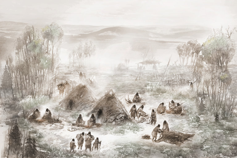
Reconstruction of the Upward Sun River base camp in what is now Alaska.
When scientists recently sequenced the genome of a six-week-old infant girl who lived 11,500 years ago at an Alaskan site now called Upward Sun River (USR), they expected that her DNA would match the genetic profile of other northern Native American people.

Instead, the genome of the infant — named Xach'itee'aanenh T'eede Gaay, meaning "Sunrise Girl-Child" and called USR1 by scientists — matched no other known ancient population.

"It was very surprising to find that USR1 belonged to a Native American population that was actually distinct from the two main Native American branches to which all Native American genomes sequenced to date belong to," J. Víctor Moreno-Mayar of the University of Copenhagen Center for GeoGenetics told Seeker.

"This means that this population was living up there, isolated from other Native American groups, for a considerably long time," he added.

Moreno-Mayar and his colleagues' findings, published in the journal Nature, support what is known as the Beringian Standstill Hypothesis. The theory holds that while all Native American ancestry can be traced back to a single East Asian source population, some descendants of this group migrated to eastern Beringia — what is now Alaska — and lived there for thousands of years.

The new paper further shows that eastern Beringia remained inhabited even after a separate branch of Native Americans had already been established in unglaciated North America.

Sunrise Girl-Child was one such early Alaskan. Her remains were found, along with those of another younger female infant named Yelkaanenh T'eede Gaay, meaning "Dawn Twilight Girl-Child," during a 2015 excavation of USR in Interior Alaska, the central region of Alaska's territory.

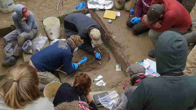
Researchers excavate the Upward Sun River infants.
The excavations were enabled by an agreement signed, in part, by the Healy Lake Tribal Council and the Tanana Chiefs Conference, which is the traditional tribal consortium of the 42 villages of Interior Alaska.

Just 200 years before the young girls' short lifetimes, the last glacial period of the Pleistocene Epoch (2.6 million–11,700 years ago) ended. A popular hypothesis known as the Bering Land Bridge Theory, first proposed in 1590 by the Spanish missionary Fray Jose de Acosta, posits that during the Pleistocene, Beringia was a vast super-continent that extended from Siberia to what is now the Yukon territory of Canada. The western and eastern portions of Beringia were joined by the Bering Land Bridge that was dissected at times by several rivers.

Geological evidence suggests that waters receded during the Late Pleistocene, better exposing the land bridge and easing navigation over it. Animals, including humans, could likely just walk over the natural bridge until about 10,500 years ago, when waters of the Bering Strait and the Chukchi Sea covered it.

Sunrise Girl-Child, Dawn Twilight Girl-Child, and their families stayed in Beringia, so the researchers have decided to call the population that these early people represent the Ancient Beringians.

"From archaeological data, we can say that the Ancient Beringians were likely present in Alaska from at least 12,500 to 6,000 years ago," co-lead author Ben Potter, a professor of anthropology at the University of Alaska Fairbanks, told Seeker.

"Interestingly," he added, "the tools associated with this group, including microblades, are very similar and historically related to the widespread microblade-using cultures in Northeast Asia, found in Japan, Korea, northern China and Siberia."

The genetic data shows that the two infants were probably first cousins. The DNA samples of Dawn Twilight Girl-Child were not sufficient for extensive further analysis, however, so the researchers instead focused on Sunrise Girl-Child.

Moreno-Mayar, senior author Eske Willerslev and their team compared Sunrise Girl-Child's genome sequence to a set of both ancient and contemporary genomes. The comparison suggests that the ancestors of Ancient Beringians and those of other Native Americans descended from a single founding population that first split from East Asians around 36,000 years ago, although gene flow with North Eurasians — possibly centered around Lake Baikal in southern Siberia — continued until about 25,000 years ago.

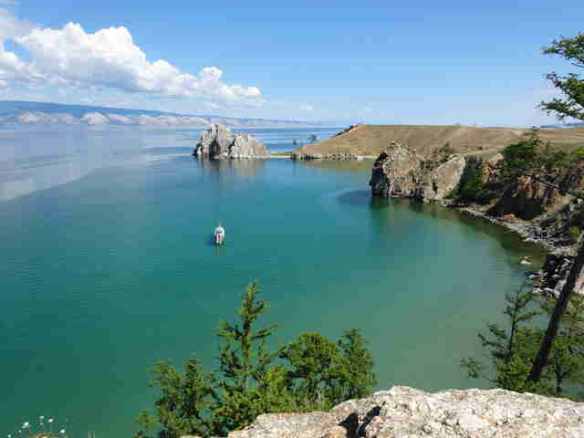
Cove at Lake Baikal in the mountainous Russian region of southern Siberia.
The founding population then split into two groups approximately 20,000 years ago, the genetic evidence suggests. According to the researchers, these groups were the newly identified Ancient Beringians and the ancestors of all other Native Americans. There are two possible explanations for where this split occurred, and how the separation affected subsequent migrations.

The first possible scenario is that Ancient Beringians and the ancestors of other Native Americans diverged somewhere in Asia 20,000 years ago. Both populations then could have moved along different routes, or at different times, through Beringia.

The second possible scenario is that Ancient Beringians and the ancestors of other Native Americans diverged in what is now Alaska 20,000 years ago. The latter group then could have moved south of the ice sheets at a later date.

"Regardless of whether scenario one or two is correct, there was a single population of ancestral Native Americans, and they at least migrated to an area where they were genetically isolated from ancestral East Asians and ancestral North Eurasians," Potter said.

Moreno-Mayar noted, "By 20,000 years ago, most of North America was covered by two vast glaciers, so whenever Native Americans made it to Alaska, they most likely still had to wait until a viable route into mid-latitude America was made available."

As for why people then migrated so much, prior research suggests at least one reason. They appear to have been following the movements of prey animals. These could have included migrating schools of fish and/or terrestrial mammals such as woolly mammoths, steppe bison, and caribou.

Geological and ecological evidence suggests that the northwest American coastal route was ice-free and potentially navigable by 16,000 years ago, while the American interior was ice-free by 15,000–14,000 years ago.

A debate now exists as to precisely when humans first colonized the Americas and if those first routes were over land or water. Moreno-Mayar and his team admit that the genetic evidence cannot yet provide definitive answers to these questions.

Archaeological findings ranging from everything to an ancient fishhook to fossilized excrement provide clues, though. Evidence for human settlements at Triquet Island, Paisley Caves, and the Channel Islands along the western North American coast all date to around 13,000–14,000 years ago.

The sites Quebrada Jaguay, Quebrada Tacahuay, Quebrada Santa Julia, and Monte Verde along the western South American coast date to about 13,000 years ago.

On the eastern coast of North America, the site Page-Ladson in Florida dates to approximately 14,500 years ago. Stone tools and mastodon remains suggest that humans there were hunting big game. Yet another early site is Huaca Prieta, north of Peru, which dates to 15,000–14,500 years ago.

Taken together, the genetic and archaeological evidence then suggests that people first expanded out of Beringia by about 16,000 years ago.

Archaeologist Todd Braje of San Diego State University, who recently co-authored a paper published in Science on Native Americans, told Seeker that "the first Americans likely arrived along the Pacific Coast — not crossing the open Pacific but migrating along the Pacific Rim in boats in a step-wise fashion."

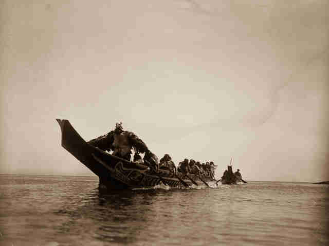
1914 image showing canoes of the Kwakiutl, an indigenous people from the Pacific Northwest Coast.
Michael Waters of Texas A&M University also favors the over water migration theory.

"The only logical way people could have come to Florida by 14,600 years ago is if their ancestors entered the Americas by boat along the Pacific Coast," Waters told Seeker. "They could have traveled by boat to central Mexico, crossed and come along the Gulf Coast. They could have entered the Americas via the Columbia River and then traveled inland to the Mississippi River and followed it down and entered the Gulf Coast, eventually making their way to Florida."

Whether or not the first continental Americans arrived in such a way, or by crossing the Bering Land Bridge, remains a mystery for now.

Even more puzzling is the controversial 130,000-year-old Cerutti Mastodon site in coastal San Diego County, California. Its discovery was announced in an April 2017 paper published in Nature. Lead author Steven Holen of the Center for American Paleolithic Research and his team reported finding "hammerstones and stone anvils" along with "spiral-fractured bone and molar fragments" of a mastodon that they believe was butchered.

"We don’t know how this animal died, " University of Michigan paleontologist Daniel Fisher, a co-author of the paper on the Cerutti Mastodon site, remarked to Seeker. "We don’t know whether humans were part of that death. All that we know is that humans came along some time after the death, and they very strategically set up a process involving the harvesting of marrow from the long bones and the recovery of dense fragments of bone that they could use as raw material for producing tools."

Such an early settlement of the Americas is not at present widely supported by other scientists. If additional evidence is found to support the claims, however, this could mean that anatomically modern humans were not the first members of the genus Homo to arrive in the New World.

Moreno-Mayar and his team did find that Sunrise Girl-Child/USR1's genome contained Neanderthal DNA. All people of Native American heritage also retain Neanderthal DNA.

"Interestingly, we found that USR1 carries a slight excess of Denisovan ancestry compared to some Native American groups," Moreno-Mayar said.

Read more at Seeker

Dec 20, 2017

Easter Island had a cooperative community, analysis of giant hats reveals

Pukao are large, cylindrical stones made from a volcanic rock known as 'red scoria.' Weighing multiple tons, they were placed on the heads of the moai during prehistoric times, consistent with the Polynesian traditions of honoring their ancestors.
Analysis of giant stone hats found on Rapa Nui, Chile (Easter Island) provides evidence contrary to the widely held belief that the ancient civilization had a warrior culture. According to a new study conducted by a team of researchers, including a professor at Binghamton University, State University of New York, these stone hats suggest that the people of Rapa Nui were part of a supportive and inclusive community.

Carl Lipo, anthropology professor and director of the Environmental Studies Program at Binghamton University, and a team of researchers studied the monumental statues (moai) on Rapa Nui, and the previously unacknowledged giant stone hats (pukao) that were placed atop them. Pukao are large, cylindrical stones made from a volcanic rock known as 'red scoria.' Weighing multiple tons, they were placed on the heads of the moai during prehistoric times, consistent with the Polynesian traditions of honoring their ancestors.

The researchers produced the first study analyzing the pukao and their significance, examining the 70 multi-ton giant hats scattered around the island that have gradually eroded over time. Using photography to produce 3D computer models, the researchers were able to study the pukao in greater detail and discovered that there are far more drawings carved into the hats than was previously thought.

"With the building mitigating any sense of conflict, the moai construction and pukao placement were key parts to the success of the island," said Lipo. "In our analysis of the archaeological records, we see evidence that demonstrates the prehistoric communities repeatedly worked together to build monuments. The action of cooperation had a benefit to the community by enabling sharing of information and resources."

While Easter Island is famous, the archaeological record of the island is not well-documented, said Lipo. He believes that scientists can learn a great deal from the pukao by examining this new information.

Read more at Science Daily

Dec 17, 2017

Ancient feces reveal parasites described in earliest Greek medical texts

Ancient faeces from prehistoric burials on the Greek island of Kea have provided the first archaeological evidence for the parasitic worms described 2,500 years ago in the writings of Hippocrates -- the most influential works of classical medicine.

University of Cambridge researchers Evilena Anastasiou and Piers Mitchell used microscopy to study soil formed from decomposed faeces recovered from the surface of pelvic bones of skeletons buried in the Neolithic (4th millennium BC), Bronze Age (2nd millennium BC) and Roman periods (146 BC -- 330 AD).

The Cambridge team worked on this project with Anastasia Papathanasiou and Lynne Schepartz, who are experts in the archaeology and anthropology of ancient Greece, and were based in Athens.

They found that eggs from two species of parasitic worm (helminths) were present: whipworm (Trichuris trichiura), and roundworm (Ascaris lumbricoides). Whipworm was present from the Neolithic, and roundworm from the Bronze Age.

Hippocrates was a medical practitioner from the Greek island of Cos, who lived in the 5th and 4th centuries BC. He became famous for developing the concept of humoural theory to explain why people became ill.

This theory -- in which a healthy body has a balance of four 'humours': black bile, yellow bile, blood and phlegm -- remained the accepted explanation for disease followed by doctors in Europe until the 17th century, over 2,000 years later.

Hippocrates and his students described many diseases in their medical texts, and historians have been trying to work out which diseases they were. Until now, they had to rely on the original written descriptions of intestinal worms to estimate which parasites may have infected the ancient Greeks. The Hippocratic texts called these intestinal worms Helmins strongyle, Ascaris, and Helmins plateia.

The researchers say that this new archaeological evidence identifies beyond doubt some of the species of parasites that infected people in the region. The findings are published today in the Journal of Archaeological Science: Reports.

"The Helmins strongyle worm in the ancient Greek texts is likely to have referred to roundworm, as found at Kea. The Ascaris worm described in the ancient medical texts may well have referred to two parasites, pinworm and whipworm, with the latter being found at Kea," said study leader Piers Mitchell, from Cambridge's Department of Archaeology.

"Until now we only had estimates from historians as to what kinds of parasites were described in the ancient Greek medical texts. Our research confirms some aspects of what the historians thought, but also adds new information that the historians did not expect, such as that whipworm was present."

The mention of infections by these parasites in the Hippocratic Corpus includes symptoms of vomiting up worms, diarrhea, fevers and shivers, heartburn, weakness, and swelling of the abdomen.

Descriptions of treatment for intestinal worms in the Corpus were mainly through medicines, such as the crushed root of the wild herb seseli mixed with water and honey taken as a drink.

"Finding the eggs of intestinal parasites as early as the Neolithic period in Greece is a key advance in our field," said Evilena Anastasiou, one of the study's authors. "This provides the earliest evidence for parasitic worms in ancient Greece."

Read more at Science Daily

Dec 11, 2017

King Tut's Jewelry and Other Bronze Age Treasures Contain Meteorites

Dagger of Emperor Jahangir, Mughal dynasty, 1621, India. The watered steel blade contains meteoric iron, iron hilt, and a gold inlay.
King Tutankhamun, Mughal Emperor Jahangir, and the legendary King Arthur all had at least one thing in common: They wielded swords made out meteoric iron.

The sturdy metal then and now inspires admiration and awe, given that it is a native metal found in meteorites, which fell from the sky and landed on Earth. It is possible that one of the world's most sacred religious objects, the Black Stone at the Grand Mosque in Mecca, contains the mystical metal, but scientists continue to debate the stone's composition.

New research, however, has just confirmed that multiple Bronze Age artifacts, including King Tut's dagger, bracelet, and headrest, contain meteoric iron. The paper, published in the Journal of Archaeological Science, describes a new geochemical approach for evaluating iron to determine if it was derived from a meteorite or smelting.

In short, the technique can distinguish extraterrestrial from terrestrial iron.

"I show that there is not a single piece of evidence for smelting in the Bronze Age on the one hand, and on the other that all Bronze Age artifacts analyzed properly are made of meteoric iron," author Albert Jambon of the French National Center for Scientific Research, the Sorbonne, and the University of Côte D'Azur told Seeker. "Once they discovered smelting, this is what we call the Iron Age," he continued. "The ability to smelt took some time to propagate from the Near East to north, west, east, and south."

Albert Jambon analyzing a meteorite at Poznan University, Poland
It is not just a novelty then to identify meteorite materials in ancient objects. The research is helping to determine precisely when and where iron smelting first occurred. As Jambon said, "Archaeologists think this happened somewhere in the Near East, sometime about 1200 BC, but we don't know for sure."

The various ages in time named after materials — such as the Stone Age, Bronze Age, and Iron Age — all marked technological advancements that changed the way people made tools, weapons, and dwellings. Just as the Computer Age has changed life as we know it, so too did these different periods affect everything from warfare to cooking.

Since iron smelting requires precise heating and melting of its oxide ore, its emergence marked a great innovation that also affected working with other base metals. The metals that make bronze are more easily recovered from their ores, and the resulting alloy in ancient times was soft enough to be easily worked with tools available then. These properties of bronze led to its namesake age, which lasted from about 3200–500 B.C., depending on the region.

Some historians have claimed that Bronze Age irons were smelted. To investigate the matter, Jambon studied a variety of artifacts containing iron from that time. They included beads from Gerzeh (Egypt, 3200 BC), a dagger from Alaca Höyük (Turkey, 2500 BC), a pendant from Umm el-Marra (Syria, 2300 BC), an axe from Ugarit (Syria, 1400 BC), several items from the Shang Dynasty civilization (China, 1400 BC), and the dagger, bracelet, and headrest of Tutankhamen (Egypt, 1350 BC).

Albert Jambon analyzing Bronze Age artifacts at Poznan University, Poland
Jambon conducted a non-destructive chemical analysis of each item utilizing a portable X-ray fluorescence spectrometer. He determined that the artifacts were made with meteoric iron, which he said has higher levels of nickel and cobalt, and exhibits no signs of having undergone smelting.

While the artifacts all passed the test, Jambon admitted that severely corroded meteorite iron can be difficult to distinguish from smelted iron. The incomplete corrosion of some of the artifacts still permitted analysis of their composition.

Jambon said working with iron from meteors required cold-hammering it or heating it before hammering. Egyptian tablets, he said, mention that metals were "taken from the furnace" before shaped into objects. Gold likely received a similar treatment.

"Bronze Age people were skillful jewelers, using not only gold, but also silver," Jambon said. "Meteorite iron is often associated with gold."

Close-up of an iron-containing meteorite. The surface features numerous thumbprint-like impressions known as regmaglypts that were formed as the meteor passed through Earth's atmosphere.
In fact, the cost of iron during the Bronze Age was ten times that of gold due to its rarity. According to the Meteoritical Bulletin Database, there are only about 1,000 documented records of iron-containing meteorites. Their weights range from 60 tons to less than half an ounce.

"Most of them are 'finds,' meaning that nobody witnessed the falling meteorite, which could be as old as tens of thousands of years," Jambon said.

In the future, he and other scientists hope to be able to link meteoric iron to its source meteors. He is also hoping to better pinpoint when and where the first iron smelting occurred.

Read more at Seeker

Nov 28, 2017

How Himalayan rivers influenced ancient Indus civilization settlements

Remnant of a street in the urban centre of Kalibangan. The Ghaggar-Hakra palaeochannel can be seen in the distance.
The Indus or Harappan Civilisation was a Bronze Age society that developed mainly in the northwestern regions of South Asia from 5300 to 3300 years ago, at about the same time as urban civilisations developed in Mesopotamia and Egypt. Archaeological evidence shows that many of the settlements in the Indus Civilisation developed along the banks of a river called the Ghaggar-Hakra in northwest India and Pakistan.

It has generally been thought that this was a major Himalayan river that dried up either due to climatic or tectonic changes. However, until now, scientists had not pinpointed how long ago the river dried up, and had assumed that it flowed while the Indus urban centres grew, playing an active role in their development.

A new study, led by researchers from Imperial College London and the Indian Institute of Technology Kanpur, has now provided evidence that a major Himalayan river did not flow at the same time as the development of Indus Civilisation urban settlements. This research shows how ancient urban centres didn't necessarily need an active, flowing river system in order to thrive.

Professor Sanjeev Gupta, lead author from Department of Earth Science and Engineering at Imperial, said: "The findings challenge our current understanding of how urbanisation in many ancient civilisations began and grew in relation to natural resources. Contrary to current belief, it was the departure of a large river, rather than its arrival, that triggered the growth of Indus urban centres."

Today's study, published in the journal Nature Communications, shows that a major Himalayan river, the Sutlej River, used to flow along the trace of the Ghaggar-Hakra river but rapidly changed course upstream eight thousand years ago. This meant that three thousand years later, when the Indus people settled the area, there was only an abandoned large river valley occupied by seasonal monsoon river flow instead of a large Himalayan river.

The researchers say the time gap between the river shifting course and the Indus Civilisation settlements appearing rules out the existence of a Himalayan-fed river that nourished Indus Civilisation urban settlements along the river channel.

The team were also able to pinpoint what the original source of the river sediments had been, showing that the Himalayan Sutlej River had once flowed along the Ghaggar-Hakra dried river channel, or palaeochannel.

They found that after the Sutlej River changed course, the scar it left in the landscape acted as a topographic low to capture river flow during the monsoon. This meant that despite not living along a permanent river, the Indus settlements still benefited from a water source.

Professor Rajiv Sinha, co-author from the Indian Institute of Technology Kanpur, said: "We now know that, given the right conditions, valleys that have lost their rivers can still serve as a water source. The civilization would also not have been threatened by the risk of devastating floods that living next to a big river brings."

To determine the timing of the river, the team drilled cores through the dried Ghaggar-Hakra river bed and analysed the layers of river sediments that had built up over time. To find out when the sediments had been deposited by the river while it was flowing, they dated mineral grains extracted from the sediment, which was carried out at the DTU-Aarhus Risø laboratory in Denmark.

When sediments are buried beneath the ground, natural background radiation results in energy being stored in mineral grains such as quartz and feldspar. If the mineral grains are not exposed to light the amount of energy builds up and represents the amount of time since their burial.

Scientists can then measure the stored energy in the laboratory and pinpoint when the layers of sediment were buried. This method, called optically stimulated luminescence dating, can therefore tell them when the river last flowed.

The team were also able to determine where the original material in the river came from by dating mineral grains such as zircon and mica, revealing the previous course of the river.

Read more at Science Daily

Nov 27, 2017

Unique metal artifacts from Iron Age settlement shed new light on prehistoric feasting

Caption This is a copper alloy horn-cap ULAS.
A unique collection of Iron Age metal artefacts which sheds new light on feasting rituals among prehistoric communities has been discovered by archaeologists from the University of Leicester during an excavation at Glenfield Park, Leicestershire.

The team, from the University of Leicester Archaeological Services (ULAS), has located a trove of ancient treasures at the site, including eleven complete, or near complete, Iron Age cauldrons, fine ring-headed dress pins, an involuted brooch and a cast copper alloy object known as a 'horn-cap', which may have been part of a ceremonial staff, emphasising the unusual nature of the metalwork assemblage.

The collection is unprecedented in terms of the overall mix of findings, with the cauldrons highlighting the role of the settlement as a potential host site for feasting, with associated traditions of ritual deposition of important objects.

The project took place over the winter of 2013/14 and was commissioned in advance of Glenfield Park, a large-scale warehouse and distribution development by Wilson Bowden Developments Ltd. close to the M1, and between the villages of Glenfield and Kirby Muxloe, both situated on the urban fringes of Leicester.

The excavation has revealed evidence for long-term landscape inhabitation throughout most of the Iron Age and Roman periods, across an area of c. 12ha, with the main focus being a dense c. 4ha spread of settlement remains comprising many roundhouses, enclosures, 4-post structures and pits that occupied the southern slopes of a low spur of slightly higher ground at the northern end of the development area.

The cauldrons and other finds at Glenfield Park are the result of a series of events that took place over a considerable length of time and have resulted in multiple episodes of deposition across the settlement.

These repeated acts mark the site out as a potential ritual and ceremonial centre that also hosted large feasts.

John Thomas, director of the excavation and Project Officer from the University of Leicester Archaeological Services, said: "Glenfield Park is an exceptional archaeological site, with a fantastic array of finds that highlight this as one of the more important discoveries of recent years. Early occupation of the site during the earlier middle Iron Age (5th -- 4th centuries BC) was relatively modest, consisting of a small open settlement that occupied the south-facing, lower slopes of the spur. Slightly later in the middle Iron Age, indicated to be in the 4th or 3rd centuries BC by radiocarbon dating, the settlement underwent striking changes in character. Individual roundhouses were now enclosed, there was far more evidence for material culture, and rituals associated with the settlement involved apparently deliberate burial of a striking assemblage of metalwork.

"It is the metalwork assemblage that really sets this settlement apart. The quantity and quality of the finds far outshines most of the other contemporary assemblages from the area, and its composition is almost unparalleled. The cauldron assemblage in particular makes this a nationally important discovery.

"They represent the most northerly discovery of such objects on mainland Britain and the only find of this type of cauldron in the East Midlands."

Most of the cauldrons appear to have been deliberately laid in a large circular enclosure ditch that surrounded a building. They had been placed in either upright or inverted positions, before the ditch was filled in, suggesting that they were buried to mark the cessation of activities associated with this part of the site. Other cauldrons were found buried across the site, suggesting that significant events were being marked over a long period of time as the settlement developed.

The cauldrons are made from several separate parts, comprising iron rims and upper bands, hemispherical copper alloy bowls and two iron ring handles attached to the upper band.

They appear to have been a variety of sizes, with rims ranging between 360mm and 560mm in diameter, with the total capacity of all cauldrons being approximately 550 litres, which illustrates their potential to provide for large groups of people that may have gathered at the settlement from the wider Iron Age community of the area.

John said: "Due to their large capacity it is thought that Iron Age cauldrons were reserved for special occasions and would have been important social objects, forming the centrepiece of major feasts, perhaps in association with large gatherings and events.

"The importance of cauldrons as symbolic objects is reflected in their frequent appearance in early medieval Irish and Welsh literature, which has been drawn upon in studies of Iron Age society. They are rarely found in large numbers and, with the exception of a discovery in Chiseldon, where 17 cauldrons were found in a pit, there have been few excavated examples in recent years."

The cauldrons are extremely fragile and were lifted from site in soil blocks for later analysis.

They were initially investigated at Paul Strickland Scanner Centre in Middlesex, a leading medical imaging centre specialising in cancer which had CT-scanning equipment large enough to accommodate the soil blocks.

Dr Andrew Gogbashian, Consultant Radiologist at Paul Strickland Scanner Centre, said: "We have the latest CT scanning technology and using our medical imaging skills and experience to contribute to such a significant archaeological discovery is a real privilege."

The scans provided useful information in terms of the cauldron orientation, approximate dimensions and profiles, as well as tantalising glimpses of manufacturing methods. Most excitingly the scans also revealed exceptionally rare evidence for decoration from the period, further highlighting the significance of the site.

One example is on a complete cauldron, which has raised stem and leaf motifs on the vessels iron band, close to the handle locations, which are similar to the so-called 'Vegetal Style' of Celtic art, generally dated to the 4th century BC. Another example of decoration has been identified on a small copper alloy bowl fragment, which has a domed rivet or raised boss decoration, suggesting that some of the bowls carried decoration too.

Further detail from the cauldrons will only be possible from excavation and conservation, which is being undertaken by MOLA (Museum of London Archaeology).

Liz Barham, Senior Conservator at MOLA said: "Already we have been able to uncover glimpses of the detailed histories of these cauldrons through CT scanning, including evidence of their manufacture and repair, and have identified sooty residues still clinging to the base of one of the cauldrons from the last time it was suspended over a fire. During the upcoming conservation we hope to discover much more about the entire assemblage. If we're lucky, we may even find food residues from the last time they were used -- over 2000 years ago."

Read more at Science Daily

Nov 16, 2017

New treasures from Tutankhamun’s tomb

Embossed gold application with motif of animal combat of Levantine origin.
As part of a German-Egyptian project, archaeologists from Tübingen for the first time examine embossed gold applications from the sensational find of 1922. The motifs indicate surprising links between the Levant and the Egypt of the pharaohs.

Researchers from Tübingen working on a German-Egyptian project have examined embossed gold applications from the treasure of the tomb of the pharaoh Tutankhamun for the first time. The objects come from the famed find made by English archaeologist Howard Carter in 1922. Until now, they had been held in storage at the Egyptian Museum Cairo. They can be seen at a special exhibition at the museum which began on Wednesday. Conservators and archaeologists of the Institute of Ancient Near Eastern Studies (IANES, Professor Peter Pfälzner), the German Archaeological Institute, Cairo, (DAI, Professor Stephan Seidlmayer), and the Römisch-Germanischen Zentralmuseums Mainz (RGZM, Professor Falko Daim), as well as the Egyptian Museum have spent four years (2013-2017) analysing the find.

Through painstaking hours in the lab, the partners restored the objects at the Egyptian Museum. They also made drawings of the items and did comprehensive research on them. A team of conservators, Egyptologists and specialists in Near Eastern archaeology found the embossed gold applications in the same crate they were placed in by Howard Carter's team immediately after their discovery. At the time, the artefacts were photographed and packed, unrestored, and were never again removed until this project.

During years of detail work, conservators Christian Eckmann and Katja Broschat of the Römisch-Germanischen Zentralmuseum Mainz reassembled the fragments to produce 100 nearly complete embossed gold applications. They suspect the items are decorative fittings for bow cases, quivers and bridles. IANES archaeologists from Tübingen examined the images on the embossed gold applications and categorized them from an art-historical perspective. In her dissertation, doctoral candidate Julia Bertsch succeeded in distinguishing the Egyptian motifs on the embossed gold applications from those that could be ascribed to an "international," Middle Eastern canon of motifs.

Among these are images of fighting animals and goats at the tree of life that are foreign to Egyptian art and must have come to Egypt from the Levant. "Presumably these motifs, which were once developed in Mesopotamia, made their way to the Mediterranean region and Egypt via Syria," explains Peter Pfälzner. "This again shows the great role that ancient Syria played in the dissemination of culture during the Bronze Age."

Interestingly, he adds, similar embossed gold applications with thematically comparable images were found in a tomb in the Syrian Royal city of Qatna. There, the team of archaeologists from Tübingen led by Pfälzner, discovered a pristine king's grave in 2002. It dates back to the time of around 1340 B.C., so it is just a bit older than Tutankhamun's tomb in Egypt. The archaeologist says, "This remarkable aspect provided the impetus for our project on the Egyptian finds." Now," says Pfälzner, "we need to solve the riddle of how the foreign motifs on the embossed gold applications came to be adopted in Egypt." The professor says that here, chemical analyses have been illuminating. "The results showed that the embossed gold applications with Egyptian motifs and the others with foreign motifs were made of gold of differing compositions," he says. "That does not necessarily mean the pieces were imported. It may be that various local workshops were responsible for producing objects in various styles -- and that one used Near Eastern models."

Read more at Science Daily

Archaeological Treasures in Iraq Unearthed Just Before Deadly 7.3 Earthquake

Neo-Assyrian cylinder seal and imprint on right, height 1.5 inches. It depicts two winged genies on a sacred tree.
Iraq is the birthplace of numerous historic firsts. It is where the sailboat, wheel, and seed plow were invented. Lying within the Fertile Crescent, it is where cereal agriculture and commercial record keeping began. Even the concept of zero and 360-degree circles were formulated in what is now Iraq.

Iraq and nearby Iran’s history are therefore of great interest to archaeologists, who often must face both manmade and natural challenges when working in the region. Earthquakes, such as the 7.3 magnitude on that struck Iran and Iraq on November 12, threaten not only people, but also invaluable archaeological artifacts that are important to the collective history of humankind.

A recent six-week excavation in the province fortuitously ended before the earthquake struck. The work focused on the 7.4-acre site Gird-î Qalrakh on the Shahrizor Plain, and unearthed evidence for an ancient, centuries-old textile industry in a region now famed for its colorful Iraqi-Kurdish carpets and related woven goods.

The discoveries almost didn't happen.

Project leader Dirk Wicke of the Institute of Archaeology at Goethe University and his team were wrapping up their excavation, when student Lanah Haddad noticed a wall from a mysterious room within the trench where she was digging. Wicke asked her to keep removing dirt. As she did, several clay weights became visible, along with the charred remains of a large ancient loom.

“Lanah worked hard with the support of 1–2 students, and I decided to leave her trench alone and open for 2 more days — which was really worth it,” Wicke told Seeker.

Backfilling of trenches following excavation
His curiosity grew over other clay objects in the trench, due to their slightly off color and texture. Similar moments have happened to him before, he said, explaining that when he sees such clues, he will try to turn the clay objects over, in order to identify possible lines, dots, and curves, which form a pattern or shape.

“Once carefully dry-cleaned in the dig house, you start to twist the find beneath strong light from all sides in order to identify the images,” he said. “In this case, they were beautiful Sasanian griffins and horses.”

Griffins — mythical creatures with the head and wings of an eagle and the body of a lion — are perhaps best known to people today from the popular Harry Potter films.

Although the lighting was poor in the tiny, cramped dig house where he and his team were based during the excavation, they were able to photograph the griffin. His team determined that the object and others found with it were probably seals from rolls of fabric.

Seal impression of griffin, c. 2cm
About 16 and a half feet below the layer where the loom and seals were discovered, the researchers found an elaborate cylinder seal dating to a much earlier time, the 9th-7th century BC Assyrian period. Assyria refers to a major Mesopotamian kingdom that, at its peak, stretched from Cyprus and the East Mediterranean to Iran, and from what is now Armenia and Azerbaijan in the Caucasus, to the Arabian Peninsula, Egypt, and eastern Libya.

The scientists were able to take a clear photo of the Assyrian cylinder seal.

"The seal was used as in modern administrative procedures — to function like a signature and authorize a treaty, letter, or other official document,” Wicke said. “One has to bear in mind, that the Assyrian documents were written in cuneiform script on wet, clay tablets, which later dried or got baked to last."

The cylinder seal depicts two winged genies with a purifying "cone" and a bucket of purifying liquid that was most likely water. The genies, he said, "flank a sacred tree expressing purification," which is "a standard topic in neo-Assyrian art."

"It is difficult to pinpoint an exact meaning to it, but this image was very often depicted in the royal palaces and appears to act as a beneficiary motif used to magically protect the king and inhabitants of the palace or palaces," he said.

On the back of this seal, opposite the tree, is a spade associated with the Babylonian god Marduk. This suggests that the seal was made and used when there were strong connections between Assyria and Babylonia, which was another ancient empire at the time.

Also dating to the 9th-7th century BC is a terraced, stone wall. The archaeologists believe it was part of a watchtower.

Wicke said that the land at the site was, and still is, "very fertile," making it an attractive location for settlement. Additionally, springs upstream of the site provide a near-continuous supply of fresh water, even during the hot and arid summer months.

It is little wonder then that people thrived on the Shahrizor plain during the much later era of the loom, which to an untrained eye looks a bit like a skeleton stretched out in a grave. The pieces instead are what is left of the large standing device that featured vertical hanging threads, which were pulled vertically straight by the clay loom weights. The threads were then woven horizontally.

"This is one of the oldest arrangements of a loom," Wicke said.

Excavated corner of room with remnants of the loom between the wall (top) and a bench of six mud bricks. The round loom weights made from clay are visible, as are slabs of mud once forming some kind of shelving.
Wicke suspected that for many centuries prior to around 4 AD it was home to a small farming community, but now they are rethinking its significance.

"It looks as if the site was taking part in a larger, overarching network of the textile trade, but this, of course, needs further examination," he said. "Why it was burnt, I really can't say."

The loom and seals came as a surprise to the researchers, who are studying the region's ceramic history that currently "still lacks a coherent pattern chronology," Wicke said. This work has been funded since 2015 by the local antiquities cervice, the Thyssen Foundation, and the Enki e.V. Association located at Goethe.

Read more at Seeker